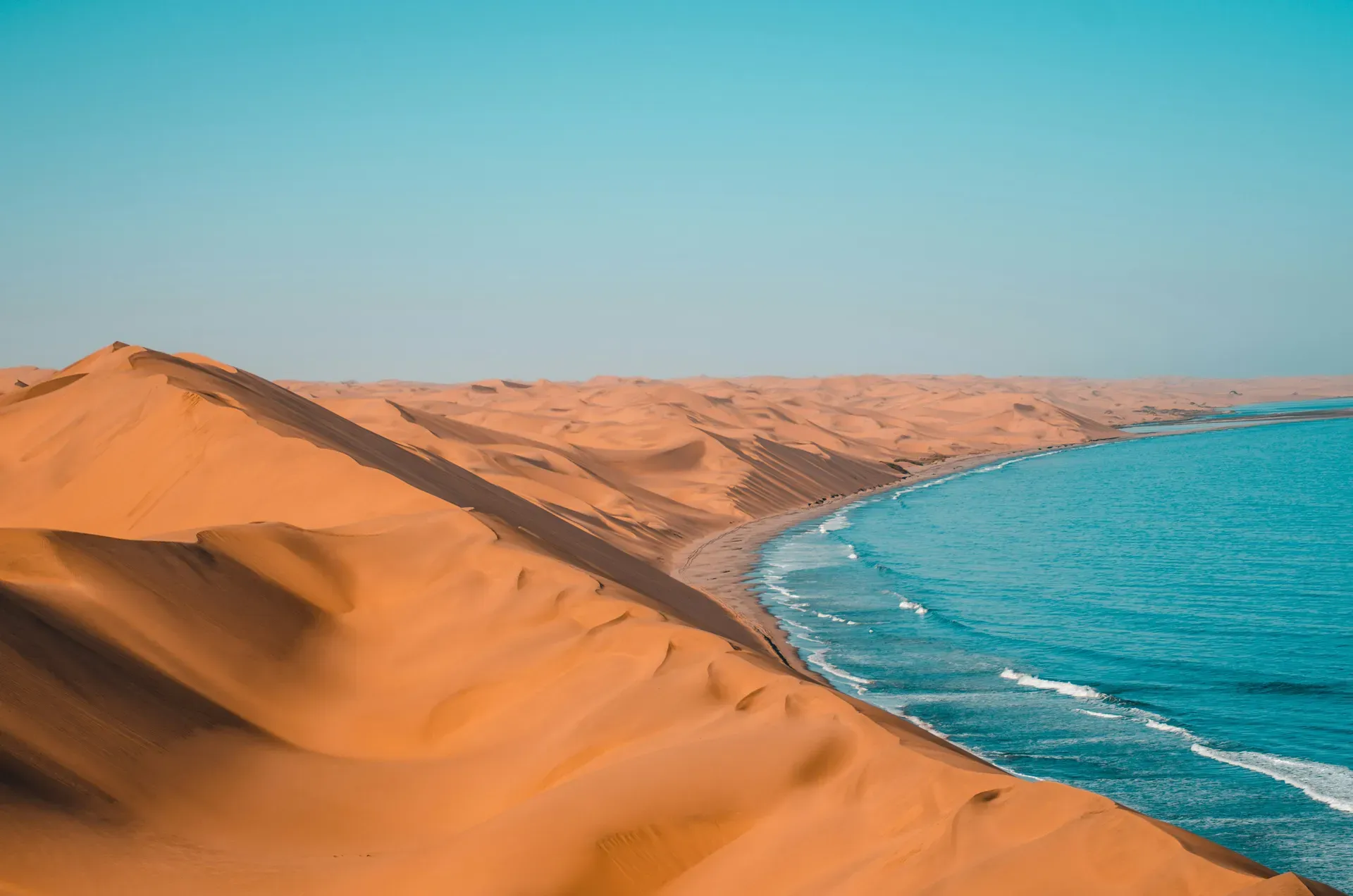
Sandwich Harbour forces 100-meter golden sand dunes directly into the Atlantic Ocean 80 kilometers south of Walvis Bay. This Ramsar wetland sustains thousands of migratory birds in a harsh desert environment where freshwater aquifers meet the sea.
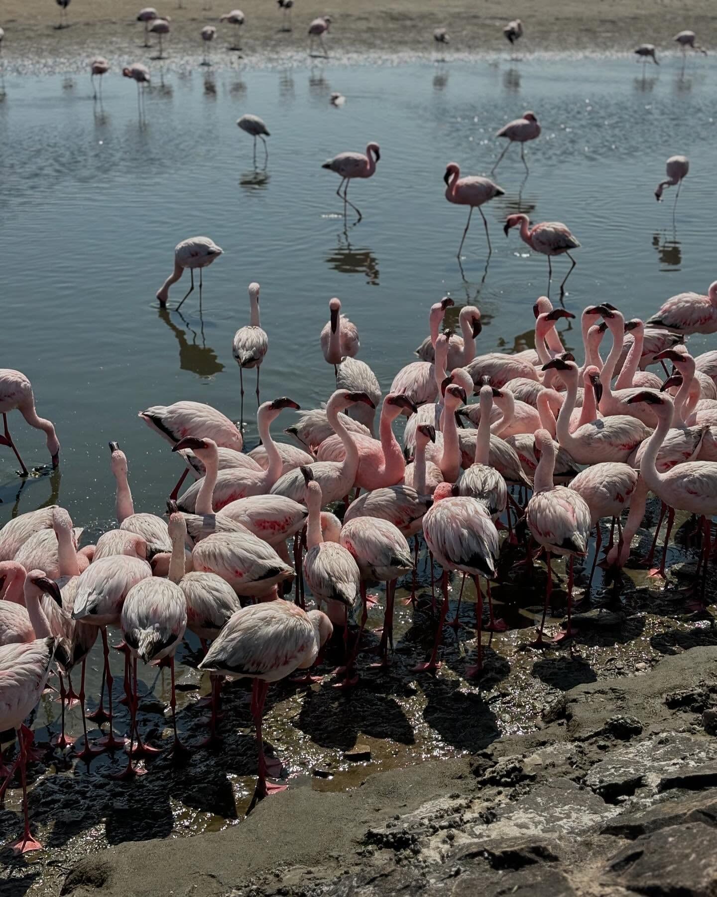
Golden sand dunes exceeding 100 meters in height crash directly into the Atlantic Ocean at Sandwich Harbour. This collision of the Namib Desert and the sea occurs 80 kilometers south of Walvis Bay inside the Namib-Naukluft National Park. The site splits into a 4.2-kilometer northern bay and a 3.7-kilometer southern lagoon. Brackish water seeps beneath the sand from underground aquifers to fill the lagoon, sustaining large reed beds in an otherwise arid landscape. Thousands of Greater and Lesser flamingos, pelicans, and Cape gulls feed in these shallow waters daily.
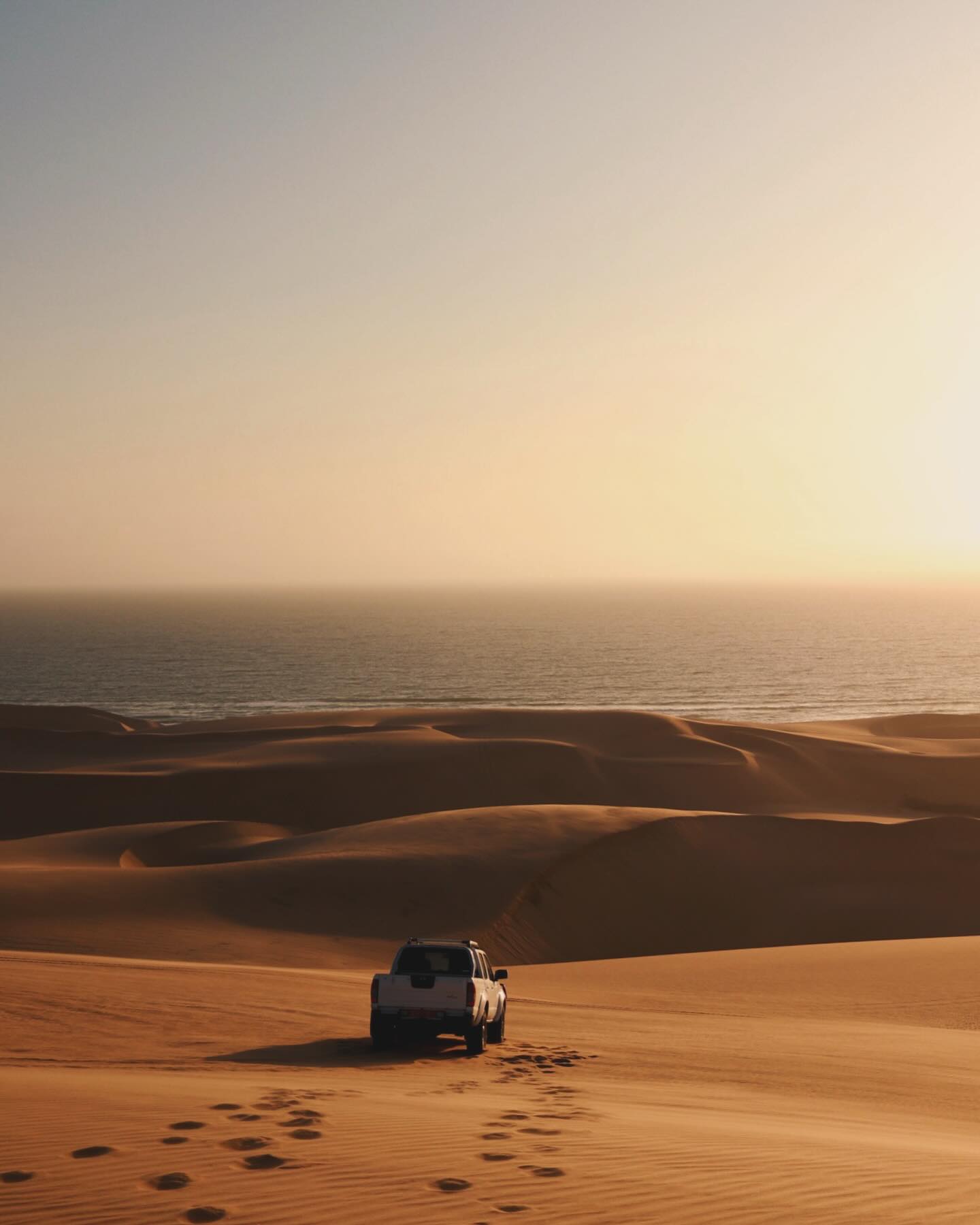
High tides regularly swallow the narrow beach access route. Drivers attempting the passage without checking the daily tide schedules often lose their vehicles to the ocean. The alternative route requires navigating 30-to-40-degree sand ridges inland. Professional guides deflate their 4x4 tires to 0.8 bar to maintain traction on these steep inclines. Fine sand blows constantly across the ridges, requiring visitors to keep camera lenses capped until the exact moment of shooting. High winds frequently whip up fine abrasive sand that can scratch camera sensors and ruin lens zoom mechanisms.
Tour operators run morning excursions starting at 8:30 AM and returning around 3:30 PM. Afternoon and sunset photography tours align with low tide schedules to ensure safe beach access. The dry winter months from June to mid-September provide the clearest skies for photography. Summer brings warmer temperatures but increases coastal fog and wind, reducing visibility along the dunes. Access requires a national park permit, and drone flights carry severe penalties, including the revocation of a guide's operating license.
Guided 4x4 tours cost between $175 and $220 USD per person depending on the duration. Self-drive guided convoys cost $150.45 USD for two people in their own vehicle. Visitors lacking a capable off-road vehicle can rent a 4x4 from the tour company for $250.75 USD per group of two. Shuttle services like Carlos Shuttle transport visitors the 400 kilometers from Windhoek to Walvis Bay for 350 NAD ($19 USD) before the 80-kilometer desert expedition begins.
Portuguese explorer Diogo Cão recorded the bay in 1486, naming it Port d’Ilheo during his voyage along the African coast. The area remained largely untouched by European sailors until the 19th century. Commercial operators soon identified the natural harbor as a strategic base along the desolate Skeleton Coast. Whalers anchored in the deep northern bay to process their catches, while other crews established guano collection camps along the shoreline. A beef canning facility operated briefly on the sand, utilizing the sheltered waters to load heavy cargo onto waiting vessels. These early industries relied entirely on the natural sand spit that shielded the inner bay from the violent Atlantic surf.
The harbor gained military and logistical importance in 1884. German colonial forces utilized the bay as a primary supply port for their expanding territory in South-West Africa. Ships dropped anchor in the deep northern bay to unload supplies destined for inland settlements. The deep water allowed large vessels to approach the shore safely, a rarity along the Namibian coastline. Swakopmund eventually replaced Sandwich Harbour as the primary port due to superior infrastructure and established overland access routes. The shift in maritime traffic left the southern bay exclusively to commercial fishing operations and local guano harvesters.
A massive sand spit protected the harbor from the Atlantic surf throughout the 19th century. This natural barrier broke apart after 1890 due to shifting ocean currents and severe coastal storms. The Atlantic immediately began depositing thousands of tons of sand into the bay, drastically reducing the water depth. Large ships could no longer enter the harbor without running aground on the newly formed sandbars. Commercial operations ceased entirely, forcing travelers to abandon the sea route and cross the desert overland. The harsh environment quickly reclaimed the canning facility and whaling camps, leaving no structural remains visible today.
The Namib-Naukluft National Park eventually absorbed the site to protect the fragile wetland ecosystem. The Namibian government secured its Ramsar Wetland status on August 23, 1995, under reference number 743. Conservationists documented the lagoon's role in supporting migratory birds, shifting the area's focus from commercial extraction to strict environmental protection. Only licensed guides operate within the boundaries today, ensuring vehicles do not disturb the breeding grounds of the coastal bird populations.
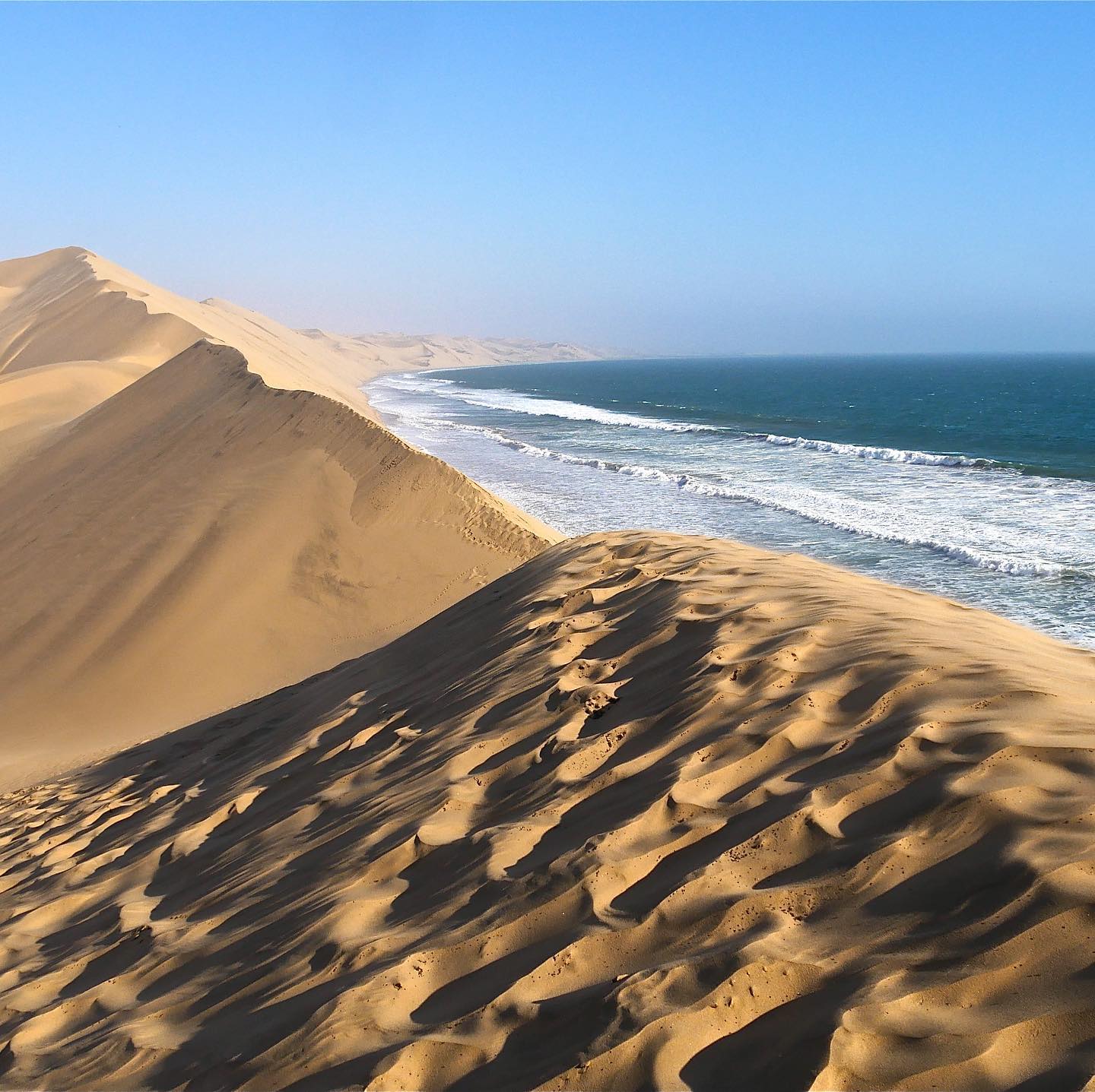
Massive slip faces of yellow sand drop at 40-degree angles straight into the Atlantic surf. The northern bay measures 4.2 kilometers long by 4 kilometers wide, dominated by these towering 100-meter dunes. Wind action constantly reshapes the crests, pushing the Namib Desert westward into the ocean at a rate of several meters per year. The collision of cold Benguela ocean currents and hot desert air generates heavy morning fog that blankets the coastline before burning off by midday. This fog provides the primary moisture source for the desert-adapted reptiles and insects living in the sand.
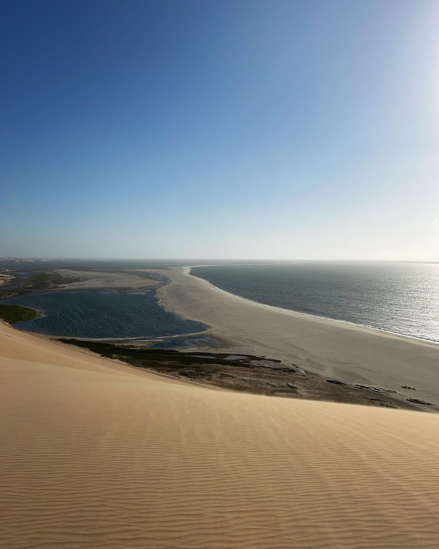
A 3.7-kilometer lagoon stretches across the southern section, measuring 1 kilometer across at its widest point. Beach ridges, swales, and saltpans separate this shallow body of water from the open ocean. Freshwater from an underground aquifer pushes up through the sand, mixing with seawater to create a brackish environment. This unique hydrological system allows dense reed beds to grow directly out of the desert floor. The vegetation anchors the surrounding sand and provides critical shelter for wetland birds against the relentless coastal winds.
Quicksand-like conditions develop along the shoreline where seawater pools invisibly beneath dry-looking surface sand. Vehicles driving off the established tracks sink to their axles in seconds, requiring heavy winching equipment for extraction. The narrow strip of drivable beach disappears entirely during high tide, forcing vehicles to climb the steep inland dune belt. Drivers must maintain precise momentum to conquer the 100-meter ascents without rolling their 4x4s backward down the slip faces.
The Pink Lakes sit further north along the route from Walvis Bay. Salt-loving microorganisms and algae dye these industrial evaporation ponds a bright magenta. The largest solar salt producer in sub-Saharan Africa operates this facility, harvesting thousands of tons of salt annually. Stepping into these lakes constitutes illegal trespassing on private property, restricting visitors to photographing the vivid water from the designated roadside pull-offs.
The indigenous Topnaar people historically utilized the ephemeral Kuiseb River delta just north of Sandwich Harbour. They harvested the !Nara melon, a spiky desert fruit that relies on the same underground aquifers that feed the coastal lagoons. The Topnaar established temporary camps along the dunes to process the melons, boiling the flesh and drying the seeds for sustenance during the dry season. While the harbor itself became a hub for European commercial extraction in the 1800s, the surrounding desert remained a harsh, unforgiving barrier that shaped local survival strategies.
Modern conservation efforts focus entirely on the site's ecological value. The August 1995 Ramsar designation recognized the lagoon as a wetland of international importance. It functions as a critical refueling stop for hundreds of thousands of migratory birds traveling the East Atlantic Flyway. Cape fur seals establish colonies along the adjacent beaches, attracting predators like black-backed jackals and brown hyenas to the shoreline. The lagoon functions as a nursery for juvenile fish species that eventually migrate into the open Atlantic.
Tour operators strictly control access to preserve this fragile dynamic. The Namibian government limits entry to licensed 4x4 guides, preventing mass tourism from degrading the dunes. Visitors must stay within designated tracks to avoid crushing the nests of ground-breeding birds or destroying the sparse vegetation that holds the ecosystem together. Collecting shells, animal bones, or desert plants carries heavy fines. Guides enforce a strict pack-in, pack-out policy, ensuring no trash remains in the park after the daily 4:00 PM departures.
Drones are strictly banned to protect birdlife, and guides lose their operating licenses if clients fly them.
The beach access route disappears completely during high tide, forcing vehicles to navigate steep inland dunes.
Brackish water in the lagoon supports massive flocks of Greater and Lesser Flamingos year-round.
A beef canning facility operated on the shoreline during the 19th century before the harbor silted up.
The coastal desert experiences rapid temperature shifts, requiring visitors to pack winter jackets and sunscreen on the same day.
Freshwater seeps under the desert dunes from underground aquifers to sustain large reed beds on the edge of the ocean.
Guides deflate 4x4 tires to 0.8 bar to climb 30-to-40-degree sand ridges without getting stuck.
Driving independently is highly discouraged due to shifting tides and deep sand. Only licensed guides can legally enter the specific harbor area. Self-drive options require joining a guided convoy.
Guided 4x4 tours run between $175 and $220 USD per person. Guided self-drive convoys cost $150.45 USD for two people using their own vehicle.
Half-day tours last approximately 4 hours. Full-day excursions that include lunch and nearby stops take 6 to 8 hours, usually returning by 4:00 PM.
The dry winter months from June to mid-September offer the best conditions. You will experience cooler temperatures, clear skies, and minimal rainfall during this period.
The national park strictly prohibits all drone flights. Tour operators will stop the tour if you attempt to fly one, as they risk losing their commercial licenses.
The lagoon supports thousands of flamingos, pelicans, and Cape gulls. Black-backed jackals, springbok, and Cape fur seals inhabit the surrounding desert and beaches.
The narrow beach passage is only passable at low tide. High tide completely submerges the route, forcing drivers to navigate the steep inland dunes to reach the viewpoints.
You cannot swim or step into the Pink Lakes. They are active industrial evaporation ponds owned by a salt company, and entering them constitutes illegal trespassing.
Dress in layers to handle rapid weather changes. Bring a windbreaker for cold morning fog and wear closed walking shoes to climb the hot sand dunes later in the day.
A protective sand spit broke after 1890, allowing ocean currents to fill the bay with sand. The water became too shallow for commercial ships to enter, shutting down the port.
Browse verified tours with free cancellation and instant confirmation.
Find Tours